Select language
Trends
Global Climate Reports
| Title |
[기타] Settlements in Focus: Combating Deforestation and Conservation in the Amazon |
|---|---|
| Category | |
|
IntroductionThe Amazon has 2,599 agrarian reform settlements,[1] which occupy 45% of the settled agrarian area in Brazil and are home to almost 400,000 families. Despite representing only 8% of the biome, the settled areas accounted for 24% of forest loss in the Amazon in 2023. In this publication, researchers from Climate Policy Initiative/Pontifical Catholic University of Rio de Janeiro (CPI/PUC-RIO) analyze the high concentration of deforestation in a small group of settlements in the Amazon and argue that targeting public policies at these critical settlements could have a significant impact on reducing forest loss in the biome. Between 2008 and 2023, the loss of forest cover in settled areas mirrored a trend observed in other areas of the Amazon biome. This suggests that similar factors influence deforestation both inside and outside agrarian reform areas. In addition, a significant portion of deforestation occurs through the removal of large areas of vegetation, a pattern that is not characteristic of small-scale farming.[2] Large-scale clearing is cost prohibitive for settlers, most of whom live in vulnerable socio-economic conditions.[3],[4] This evidence suggests that deforestation in the agrarian settlements is driven by external actors and broader dynamics, and not by the resident population. A striking feature of deforestation in settlements is its high concentration: 5% of settlements are responsible for 65% of the deforested area. Year after year, the same settlements, situated in geographic proximity, are consistently responsible for the most deforested areas. Targeted action in these critical settlements could therefore have a significant impact on reducing deforestation. Given the high concentration of forest loss in settled areas, the National Institute for Colonization and Agrarian Reform (Instituto Nacional de Colonização e Reforma Agrária – INCRA) should adopt targeted policies to promote forest conservation. INCRA is responsible for implementing agrarian reform policies and managing public lands in Brazil. In the Amazon region, its operations are organized through 11 oversight units called regional superintendencies, three of which are located in the state of Pará and one in each of the other nine states of the biome.[5] At the regional superintendency level, deforestation is also concentrated in a small number of settlements. For example, just five settlements account for 75% of deforestation in the Amazonas Superintendency. Furthermore, three of the eleven superintendencies make up 63% of deforestation in settled areas. The concentration of forest loss in agrarian reform areas has significant implications. In the context of deforestation combat policy, targeted action in priority settlements can have significant effects and should be incorporated into the strategic plans of agencies such as the Ministry of the Environment and Climate Change (Ministério do Meio Ambiente e Mudança do Clima – MMA) and the Brazilian Institute for the Environment and Natural Resources (Instituto Brasileiro do Meio Ambiente e dos Recursos Naturais – IBAMA). In the context of national agrarian reform policy, this concentration represents an opportunity for INCRA to direct its efforts towards a specific group of superintendencies and settlements. A strategic intervention by the regional superintendencies could be essential to reducing deforestation in the agrarian reform areas of the Amazon, blending environmental conservation with the socio-economic development of these regions. Agrarian Reform in the Amazon Rural settlements are areas designated for agrarian reform, in which landless families are settled in the area with a goal of cultivating the land and improving living conditions.[6] They are an essential part of Brazil’s strategy to improve land distribution and promote social justice.[7] The Amazon biome makes up 45% of the settled areas and 52% of the settlers in the country.[8] The biome is currently home to 2,599 settlements, of which 79% are conventional and 19% environmentally differentiated (Table 1).[9],[10],[11] The environmentally differentiated settlements are larger in size per family. This is consistent with the need for larger areas to develop sustainable activities. This type of settlement contains includes most of the remaining primary vegetation forest in the settled area. Table 1. Settlements in the Amazon Biome, 2024
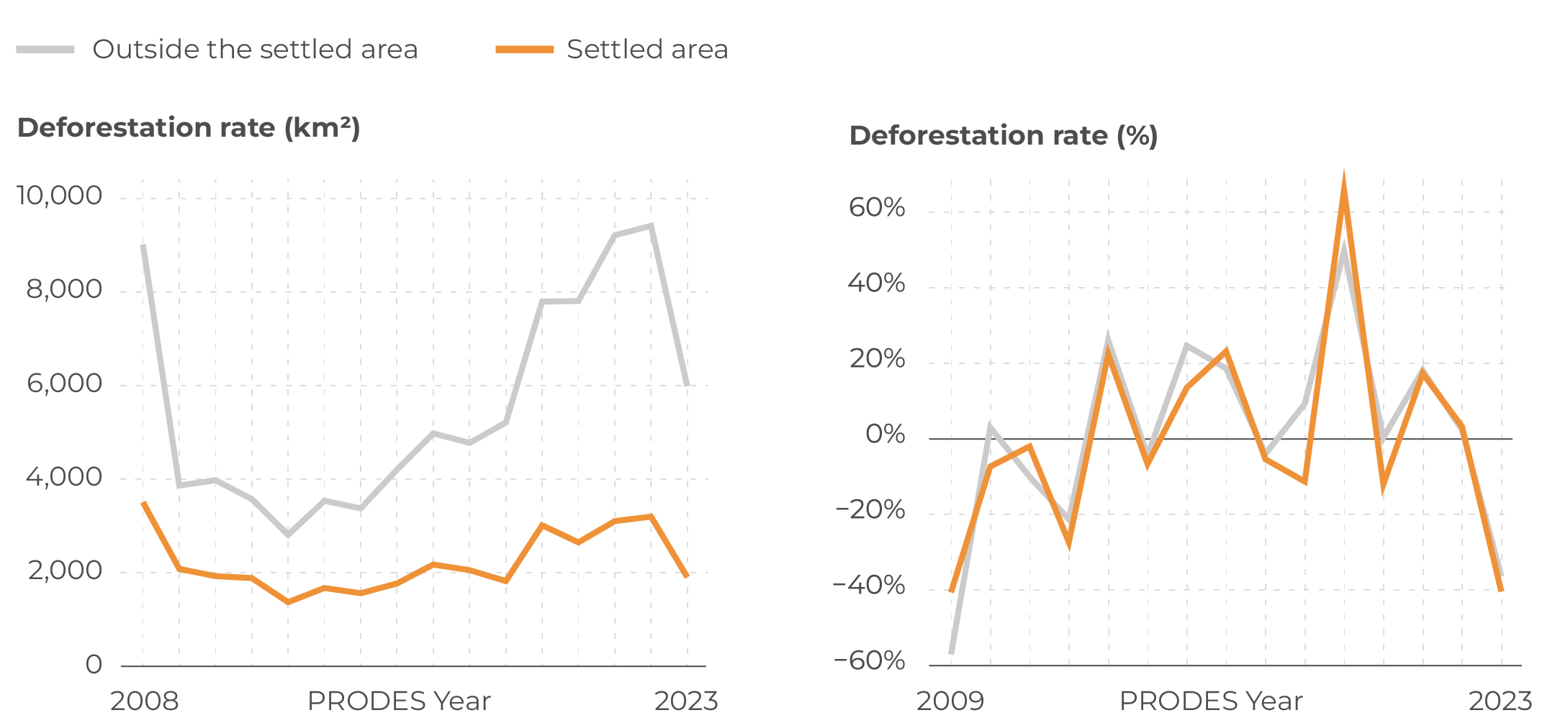
Source: CPI/PUC-Rio with data from INCRA (2023-2024), PRODES/INPE (2024), and IBGE (2019), 2024 Deforestation in the SettlementsTargeted action in agrarian reform settlements is essential to combating deforestation in the Amazon. While the settled area only represents 8% of the biome, nearly a quarter of the forest loss in 2023 occurred within it; this is consistent with observations in, previous years. Since 2008, 28% of deforestation in the Amazon has occurred in settlements.[12] Figure 1 demonstrates that deforestation inside and outside the settled areas follows similar trends. The rates of change in deforestation between 2009 and 2023 suggest that the same factors influence deforestation both inside and outside settled areas. Thus, national and regional policies to combat deforestation have an impact on forest loss in settled areas, even in the absence of specific actions aimed at these territories. Figure 1. Deforestation in the Amazon Biome, 2008-2023
Source: CPI/PUC-RIO with data from PRODES/INPE (2024), INCRA (2023-2024), and IBGE (2019), 2024 In addition, Figure 2 shows that three quarters of the vegetation loss in the settled area is the result of deforestation of areas larger than 6.25 hectares, with 36% accounting for deforestation of more than 25 hectares. This large-scale forest loss is further evidence that part of this deforestation may be propelled by external actors who are not direct beneficiaries of the national agrarian reform policy. After all, this pattern is not typical of family farming[13] and involves high costs,[14] incompatible with the socio-economic reality of the settled populations.[15] It is not by chance that this large-scale deforestation is more prevalent in the settlements that deforest the most in the biome.[16] Figure 2. Deforested Area in the Amazon Biome, by Size of Deforested Area in 2023
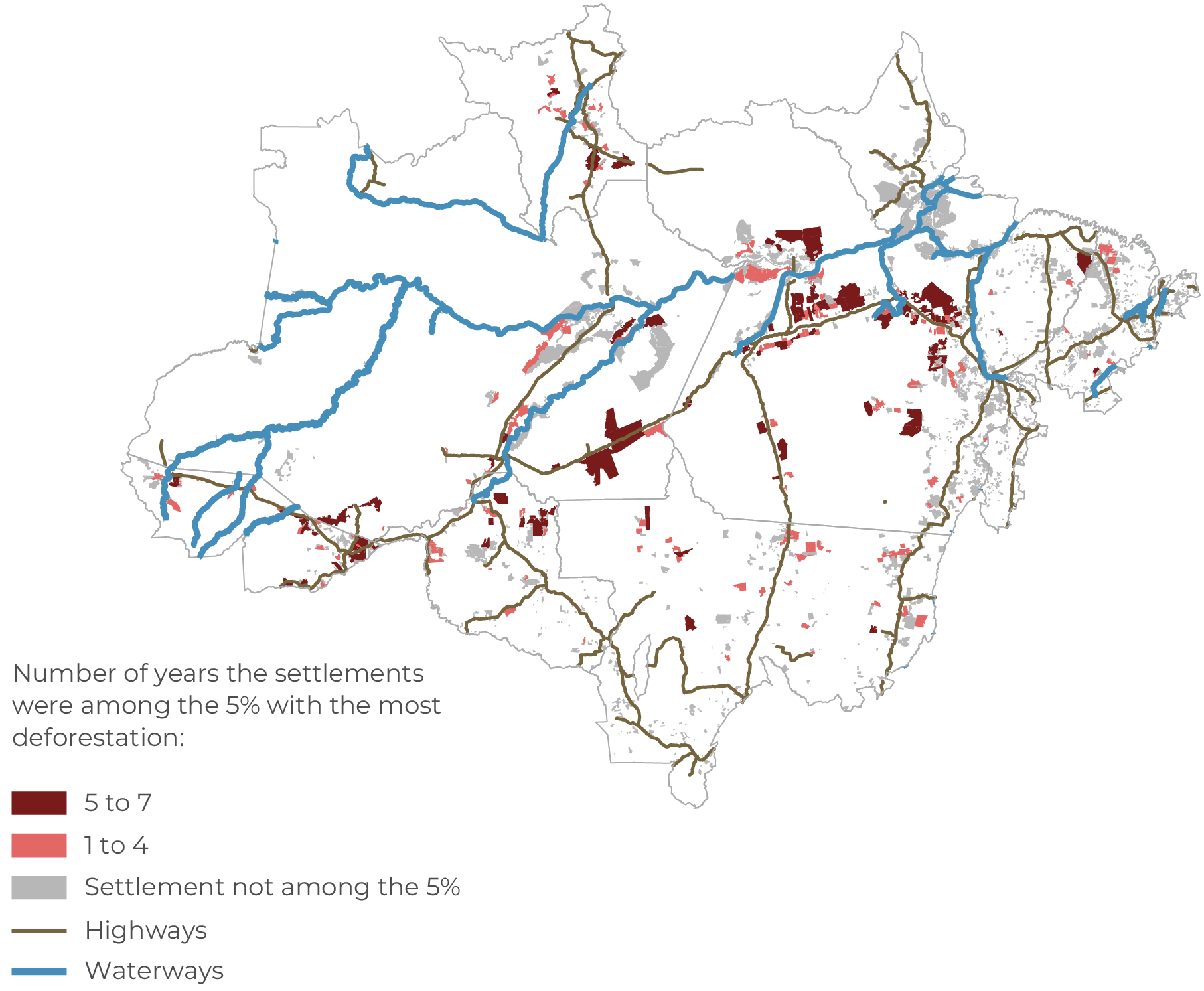
Source: CPI/PUC-RIO with data from PRODES/INPE (2024), INCRA (2023-2024), and IBGE (2019), 2024 Public policies aimed at protecting the forest in settled areas have the potential to significantly reduce the loss of native vegetation in the Amazon. Between 2017 and 2023, just 5% of settlements accounted for 65% of deforestation in settled areas and 17% of vegetation loss in the biome. As deforestation in these settled areas is concentrated, actions targeting a small number of critical settlements would have an effect on a significant portion of forest loss. Figure 3 shows all Amazon settlements and includes how many years each reached the 5% that deforested the most. Settlements with the most deforestation tend to be close to each other and in proximity to federal highways. The figure also illustrates that the same settlements make up the most loss of native vegetation over a several year period. Of the top 5% of the most deforested settlements in 2023, 49% were on this list at least five other times between 2017 and 2022. This is an indication that deforestation in the subsequent years also tends to be concentrated in these same settlements. Therefore, the development of specific action plans for these strategic regions must be a priority in order to promote Amazon conservation. Figure 3. Settlements with the Most Deforestation in the Amazon Biome, 2017-2023
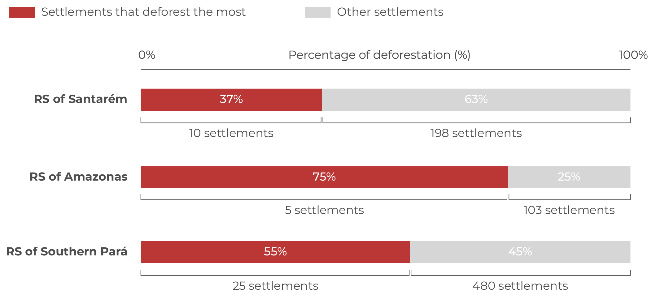
Source: CPI/PUC-RIO with data from PRODES/INPE (2024), INCRA (2023-2024), and IBGE (2019), 2024 The concentration of deforestation in settled areas has important implications for the various institutions working to conserve the Amazon, especially INCRA’s regional superintendencies. As the body responsible for the territorial management of settlements in Brazil, INCRA plays a fundamental role in promoting the best land use practices in these areas. To organize its work, the institute operates through regional superintendencies. In the Amazon, there are eleven superintendencies, three in Pará and one in each of the other states in the biome. Between 2017 and 2023, 63% of deforestation in settled areas occurred in three regional superintendencies: Santarém, Southern Pará, and Amazonas. In these three cases, most of the vegetation loss is concentrated in a small group of settlements (Figure 4). In the Santarém Superintendency, 37% of deforestation occurred in just 10 Settlement Projects. The most striking is the Liberdade I Sustainable Development Project, which is responsible for 12% of forest loss in the superintendency (Appendix A). In the Amazonas Superintendency, just five of the 108 settlements account for 75% of deforestation, 46% of which is exclusively in the Rio Juma. Meanwhile, the in the Southern Pará Superintendency, which covers 505 settlements, just 25 settlements account for 55% of the total deforestation. In addition, 35% of forest loss in this superintendency is concentrated in four settlements: Tuerê, Rio Cururuí, Rio Gelado, and Pombal. Figure 4. Concentration of Deforestation in Settlements in the Amazon Biome by Regional Superintendency (RS), 2017-2023
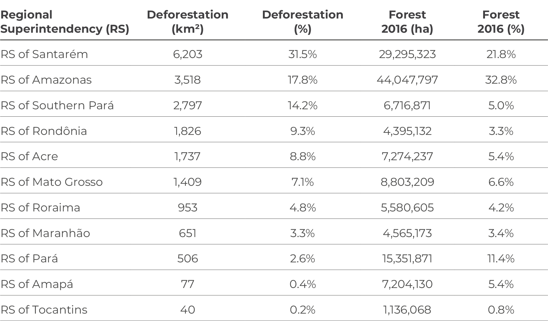
Source: CPI/PUC-RIO with data from PRODES/INPE (2024), INCRA (2023-2024), and IBGE (2019), 2024 In the case of these three superintendencies, a few settlements account for a significant portion of vegetation loss. The picture is similar in the other eight superintendencies, as detailed in Appendix A. The development of specific public policies for these critical settlements could therefore have a significant impact on deforestation in the biome. Public Policy Guidelines There are indications that deforestation in agrarian reform areas is not driven by the settled population. The size of the deforested polygons does not match the activities typically carried out by family farmers. Furthermore, deforestation within settlements follows a very similar trend to deforestation outside these areas, suggesting that external agents and broader dynamics may be driving the removal of vegetation. Policies targeted at the Amazon’s agrarian settlements could substantially reduce forest loss. Deforestation in these areas is concentrated; actions by the MMA and IBAMA focused on a small number of priority settlements can therefore have significant impacts on the biome. In addition, INCRA’s regional superintendencies play a fundamental role in forest conservation in the settled areas. Three of the eleven superintendencies face high rates of deforestation, accounting for 63% of the deforested area in these regions. These superintendencies should be prioritized and incorporate the local knowledge needed for targeted actions aimed at the small group of settlements that are most critical, ensuring greater effectiveness of the policies adopted. This report received financial support from the Institute Climate and Society (ICS), Itaúsa Institute, and Norway’s International Climate and Forest Initiative (NICFI). [1] This figure only considers settlements with georeferencing available in INCRA’s Land Collection on 04/24/2024, 02/08/2024 or 04/28/2024 that are, even partially, within the borders of the Amazon biome according to the 2019 definition by the Brazilian Institute of Geography and Statistics (IBGE). As a reference, 86% of the 9,561 settlements that appeared on INCRA’s list of projects on 28/04/2024 were considered to be georeferenced, a figure that totals 90% when considering municipalities with more than 50% of their territory in the Amazon biome. [2] Azevedo, Andrea et al. Overview of Amazon Deforestation in 2016. IPAM Amazônia, 2016. bit.ly/4hk9kKT. [3] Ferreira, Alípio. Amazon Deforestation: Drivers, damages, and policies. 2024. bit.ly/3NuQ0wQ. [4] Leite, Sérgio et al. Impactos dos Assentamentos: Um Estudo sobre o Meio Rural Brasileiro. São Paulo: Editora UNESP, 2004. bit.ly/3U7F6kj. [5] The regional superintendencies are decentralized bodies responsible for coordinating and executing INCRA’s actions in the states. These units are responsible for managing activities related to planning, budgeting, IT, and administrative modernization within their jurisdiction. Additionally, they ensure the maintenance, reliability, updating, and dissemination of data from INCRA’s rural property registry and information systems. Learn more at: INCRA. Relatório de Gestão Exercício 2015. 2015. bit.ly/3NCgnRt. [6] Chiavari, Joana, Cristina L. Lopes, and Julia N. de Araujo. Panorama dos Direitos de Propriedade no Brasil Rural. Rio de Janeiro: Climate Policy Initiative, 2021. bit.ly/PanoramaDireitosDePropriedade. [7] Souza, Maria Lucimar et al. Assentamentos Rurais da Amazônia: Diretrizes para a Sustentabilidade. Amazônia 2030, 2022. bit.ly/48kuowS. [8] IBGE. Biomes of Brazil: shapefile, 2019. 2019. Access date: September 16, 2020. bit.ly/4690QQH. [9] INCRA. Assentamentos – Relação de Projetos. 2024. Access date: September 23, 2024. bit.ly/3EjGUyv. [10] INCRA. Acervo Fundiário. Assentamentos Brasil. Access date: November 23, 2024. bit.ly/44ytbyD. [11] Conventional settlements are areas earmarked for family Agricultural production and have the same environmental requirements as private properties. Environmentally differentiated settlements, on the other hand, include forest conservation among their main objectives and favor agro-extractive production models. Conventional settlements include Settlement Projects and State Settlement Projects. Environmentally differentiated settlements include Agro-Extractivist Settlement Projects, Sustainable Development Projects and Forest Settlement Projects. The “Other” category includes Joint Settlement Projects, Directed Settlement Projects, Municipal Settlement Projects, Quilombola Settlement Projects, Rapid Settlement Projects, Cocoon Settlement Projects and Integrated Colonization Projects. [12] INPE. Terra Brasilis – Downloads. nd. Access date: July 16, 2024. bit.ly/3L7iH27. [13] Azevedo, Andrea et al. Overview of Deforestation in the Amazon. IPAM Amazônia, 2016. bit.ly/4hk9kKT. [14] Ferreira, Alípio. Amazon Deforestation: Drivers, damages, and policies. 2024. bit.ly/3NuQ0wQ. [15] Leite, Sérgio et al. Impactos dos Assentamentos: Um Estudo Sobre o Meio Rural Brasileiro. São Paulo: Editora UNESP, 2004. bit.ly/3U7F6kj. [16] Mourão, João, Marcelo Sessim, and Priscila Souza. Preserving the Amazon: Strategies to Reduce Deforestation in Rural Settlements. Rio de Janeiro: Climate Policy Initiative, 2023. bit.ly/DeforestationSettlements. [17] The exceptions are the superintendencies of Amapá and Tocantins, which together account for less than 1% of deforestation in the settled area of the biome. The other regional superintendencies are presented according to their level of deforestation, with the one that showed the most deforestation—Regional Superintendency of Santarém—appearing first, and so on. [18] The forest cover of each settlement was calculated by subtracting the area of the settlement from its non-forest areas, water areas and accumulated deforestation up to the reference year. Appendix A: Deforestation by Regional SuperintendencyThis section presents details of deforestation in the settled area of the Amazon by regional superintendency, showing the most deforested settlements.[17] Between 2017 and 2023, deforestation in the settled area of the Amazon was concentrated in the Superintendencies of Santarém, Amazonas and Southern Pará, accounting for 63% of deforestation in the region. In these three superintendencies, 5% of the settlements account for a disproportionate share of forest loss. This pattern is also seen in the other superintendencies analyzed. Table A1 shows the deforestation recorded in each Amazon superintendency between 2017 and 2023, highlighting its contribution to forest loss in the settled area. The table also shows the percentage of forests in the settled area present in the superintendency in 2016.[18] If the forest were deforested at the same rate in all settlements, the two percentages shown in the table would coincide. Therefore, a higher share of deforestation than its 2016 percentage indicates that forest loss per hectare of forest was higher than the average for the settled areas in this superintendency. The superintendencies of southern Pará and Rondônia are worth highlighting: their share of deforestation is almost three times greater than their percentage of forest in 2016. Some superintendencies, however, may have a relevant portion of their forests in areas with little pressure from agricultural activities, as is the case with the Regional Superintendency of Amazonas. Table A1. Deforestation in the Amazon Biome by Regional Superintendency, 2017-2023
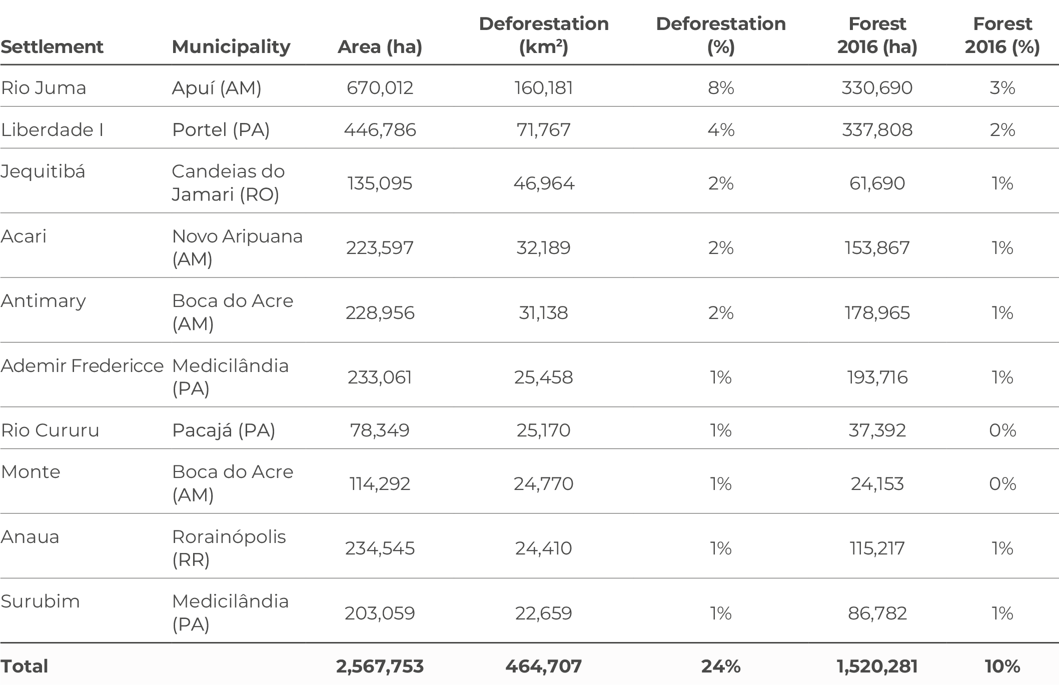
Source: CPI/PUC-RIO with data PRODES/INPE (2024), INCRA (2023-2024), and IBGE (2019), 2024 One hundred and thirty projects, making up 5% of the settlements in the Amazon, accounted for 65% of deforestation in the settled areas of the biome. Table A2 shows the 10 most deforested settlements in the biome between 2017 and 2023. Together, they accounted for 24% of forest loss in the settled areas—despite only comprising 10% of the forest stock in the biome’s settlements in 2016. However, there are still more than 1.5 million hectares of native forest vegetation in these projects, which suggests that deforestation will remain high for many years to come. Table A2. Ten Settlements with the Most Deforestation in the Amazon Biome, 2017-2023
Source: CPI/PUC-RIO with data from PRODES/INPE (2024), INCRA (2023-2024), and IBGE (2019), 2024 Regional Superintendency of SantarémThe regional superintendency with the most deforestation in the Amazon is Santarém in Pará, where there are 208 land reform settlements. Between 2017 and 2023, 31% of all forest loss in settled areas occurred in this superintendency. Deforestation in this superintendency is concentrated in just 10 settlements, responsible for 37% of deforestation in the superintendency (Figure A1). Figure A1. Settlements with the Most Deforestation in the Santarém Regional Superintendency, 2017-2023
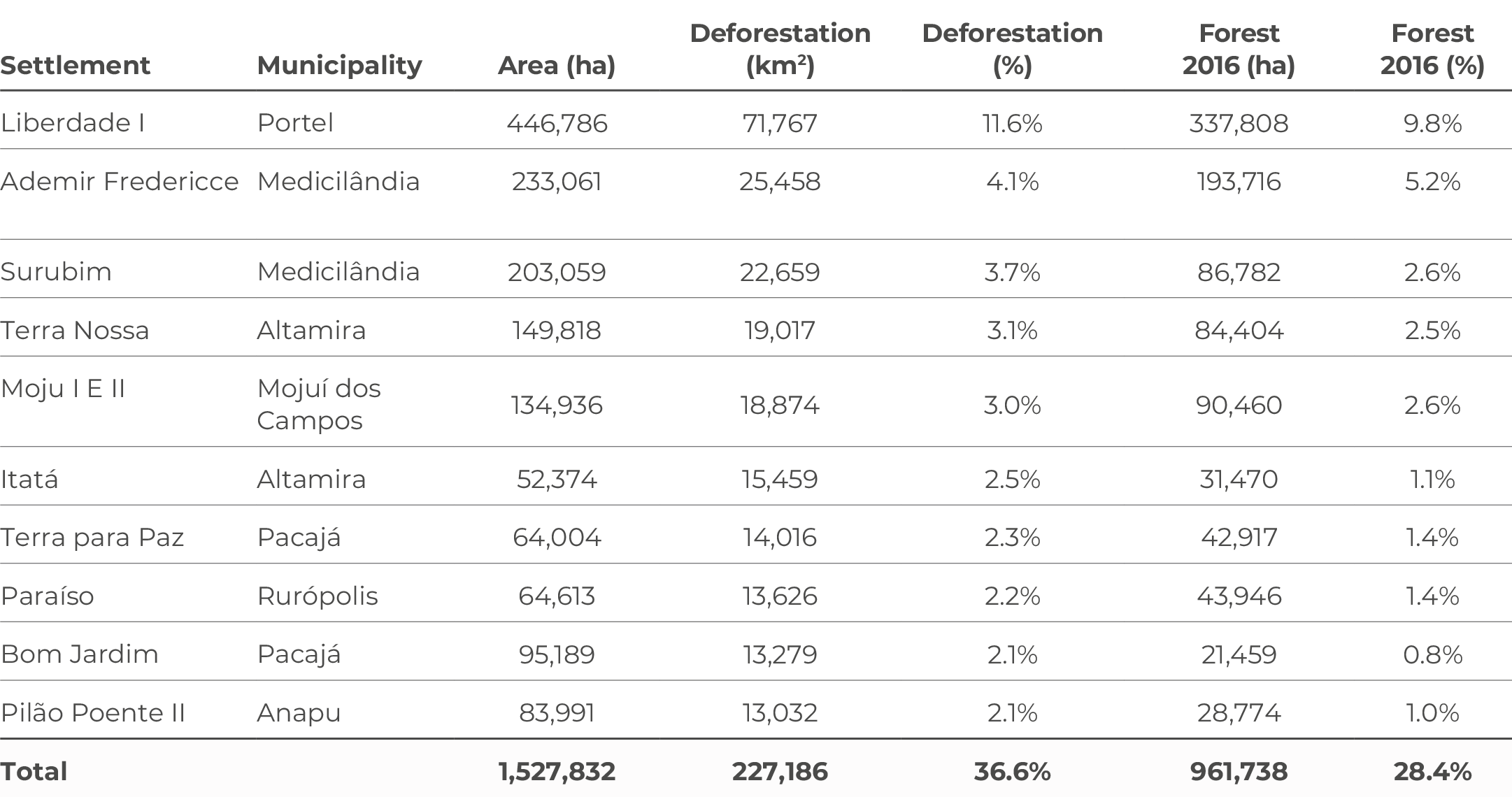
Source: CPI/PUC-RIO with data from PRODES/INPA (2024), INCRA (2023-2024), and IBGE (2019), 2024 Table A3 shows the 10 most deforested settlements in the Santarém Superintendency. Among them, the Liberdade I Sustainable Development Project stands out. With an area of approximately 450,000 hectares, it is one of the largest settlements in the region and is located in the municipality of Portel, where 12% of all forest loss occurred in the settled area under the supervision of this superintendency. With almost 340,000 hectares of forest remaining, deforestation in this settlement could remain high for some time. Table A3. Settlements with the Most Deforestation in the Santarém Regional Superintendency, 2017-2023
Source: CPI/PUC-RIO based on data from PRODES/INPE (2024), INCRA (2023-2024), and IBGE (2019), 2024 Regional Superintendency of AmazonasThe Amazonas superintendency has 108 settlements, in which 18% of forest loss occurred in the settled area of the biome. Between 2017 and 2023, 75% of this forest loss occurred in 5% of the settlements (Figure A2). These settlements are close to the southeast and southwest regions of the state, where deforestation has been greatest. Figure A2. Settlements with the Most Deforestation in the Amazonas Regional Superintendency, 2017-2023
Source: CPI/PUC-RIO with data from PRODES/INPE (2024), INCRA (2023-2024), and IBGE (2019), 2024 Table A4 shows the five settlements with the most deforestation in the Amazonas Superintendency. It also shows the settlement with the most deforestation in the country, the Rio Juma settlement. This settlement accounted for 8% of forest loss in the settled area of the biome and 46% of deforestation in the superintendency. The Rio Juma may also continue to be one of the main deforestation hotspots in the biome, as it is home to more than 330,000 hectares of forest. Table A4. Settlements with the Most Deforestation in the Amazonas Regional Superintendency, 2017-2023
Source: CPI/PUC-RIO with data from PRODES/INPE (2024), INCRA (2023-2024), and IBGE (2019), 2024 The other settlements that lead deforestation in the superintendency also account for a significant percentage of forest loss in the settled areas. The Acari and the Antimary Agro-Extractive Settlement Project together accounted for 18% of deforestation in the superintendency. Regional Superintendency of Southern ParáThe Superintendency of Southern Pará has 505 settlements, in which 14% of forest loss occurred in the settled areas of the biome. Between 2017 and 2023, the 25 settlements that lost the most vegetation account for 55% of deforestation in the superintendency. These settlements are larger than the others and are closer to the central region of the state, where there is less prevalence of consolidated areas. Figure A3. Settlements with the Most Deforestation in the Southern Pará Regional Superintendency, 2017-2023
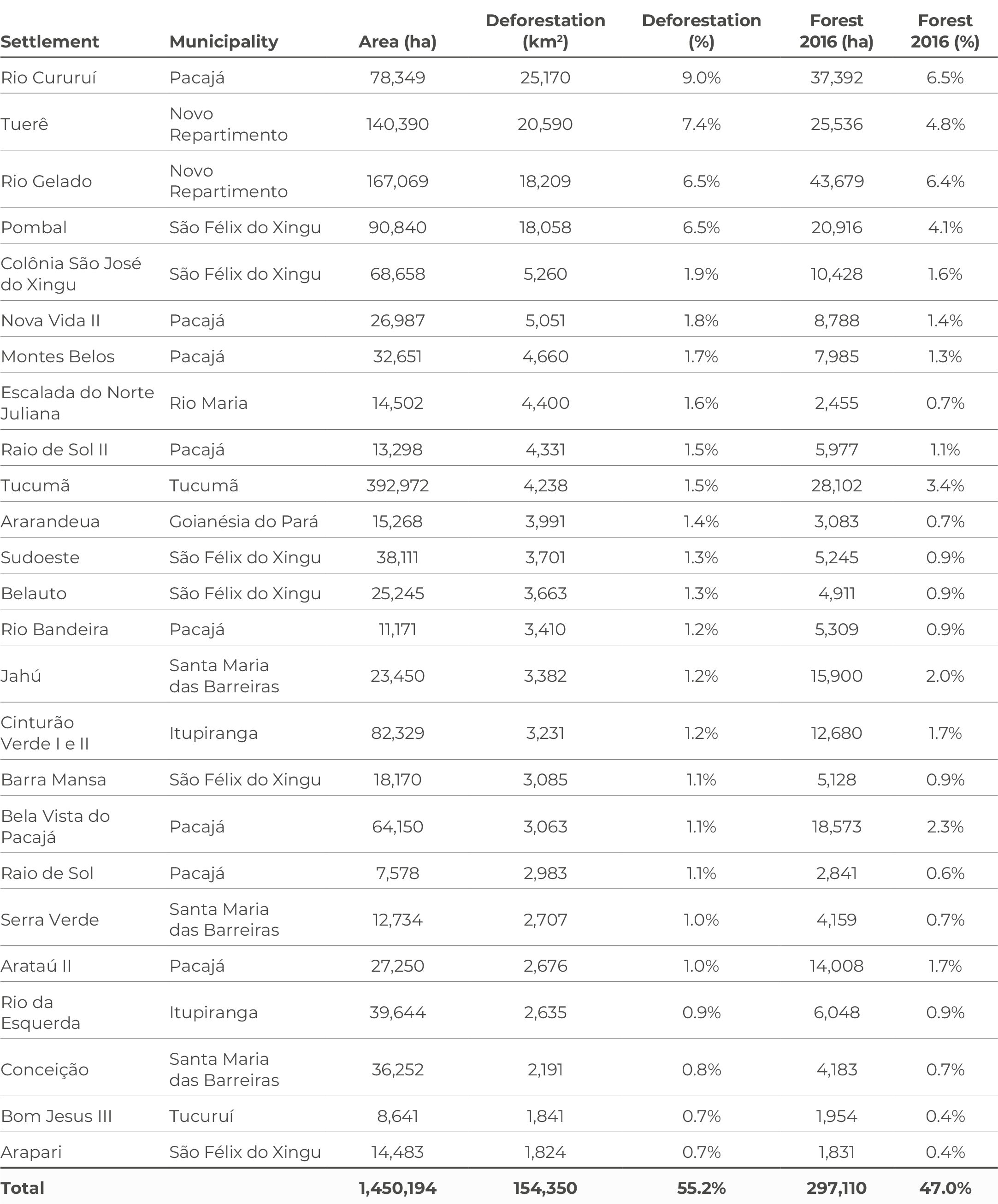
Source: CPI/PUC-RIO with data from PRODES/INPE (2024), INCRA (2023-2024), and IBGE (2019), 2024 Table A5 shows the 25 settlements with the most deforestation in the Southern Pará Superintendency. This group includes the Rio Cururuí, Tuerê, Rio Gelado and Pombal settlement projects. Together, they account for 29% of the superintendency’s forest loss. Actions targeting these four projects could have a significant impact on deforestation in the region. Table A5. Settlements with the Most Deforestation in the Southern Pará Regional Superintendency, 2017-2023
Source: CPI/PUC-RIO with data from PRODES/INPE (2024), INCRA (2023-2024), and IBGE (2019), 2024 Regional Superintendency of RondôniaThe Rondônia Superintendency, which accounts for 9% of deforestation in the settled area, also has a high concentration of deforestation. Between 2017 and 2023, more than 47% of vegetation loss occurred in just eight of its 164 settlements (Figure A4). Six of the eight are located in the municipalities of Machadinho do Oeste and Candeias do Jamari; this also demonstrates a need for targeted action. Figure A4. Settlements with the Most Deforestation in the Rondônia Regional Superintendency, 2017-2023
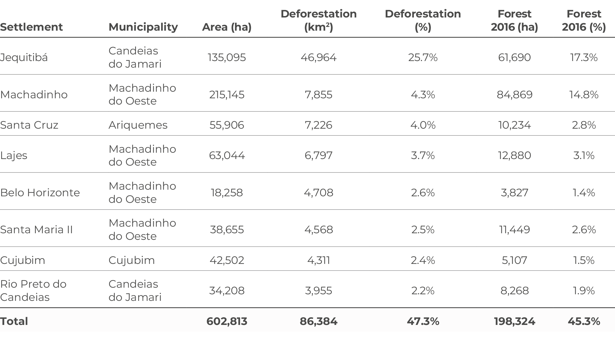
Source: CPI/PUC-RIO with data from PRODES/INPE (2024), INCRA (2023-2024), and IBGE (2019), 2024 Table A6 shows the eight settlements with the most deforestation in the Rondônia Superintendency. More than a quarter of deforestation in this superintendency occurs in the Jequitibá Forest Settlement Project, which accounts for a 2% of forest loss in the settled areas. In addition, the Machadinho, Santa Cruz and Lajes settlements have the highest rates of deforestation, respectively; the three together account for 12% of forest loss in the superintendency. Table A6. Settlements with the Most Deforestation in the Regional Superintendency of Rondônia, 2017-2023
Source: CPI/PUC-RIO with data from PRODES/INPE (2024), INCRA (2023-2024), and IBGE (2019), 2024 Regional Superintendency of AcreThe Acre Superintendency accounts for 9% of forest loss in the settled area. Between 2017 and 2023, just six of its 129 settlements accounted for 32% of deforestation (Figure A5). It is worth noting that, despite some geographical proximity, all of its settlements are in different municipalities. Figure A5. Settlements with the Most Deforestation in the Acre Regional Superintendency, 2017-2023
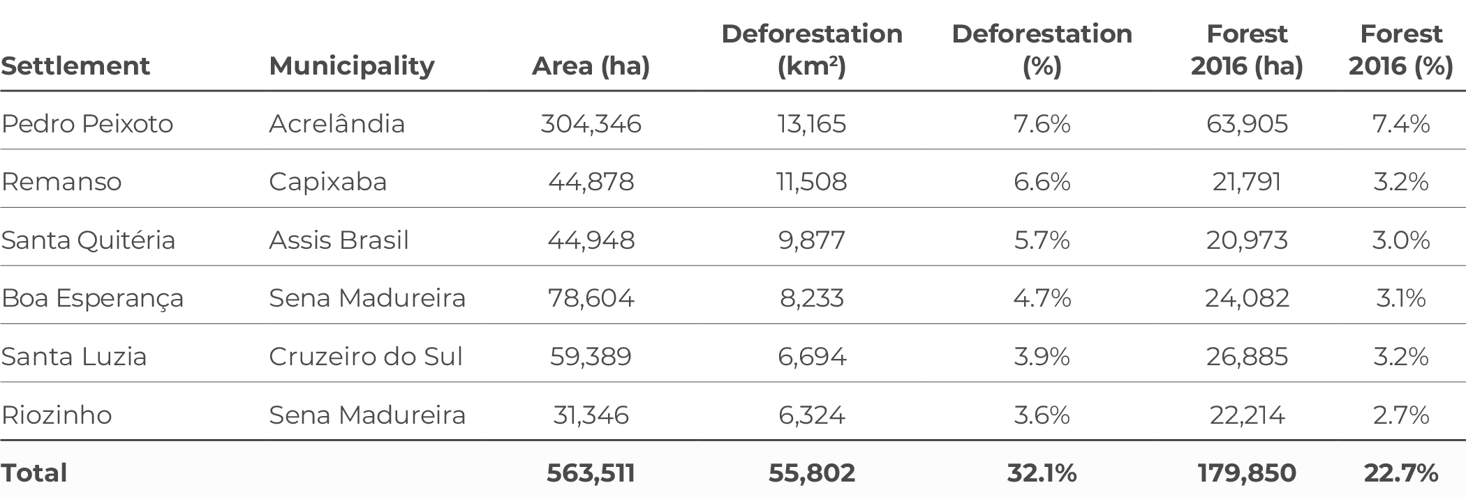
Source: CPI/PUC-RIO with data from PRODES/INPE (2024), INCRA (2023-2024), and IBGE (2019), 2024 Table A7 shows the six settlements with the most deforestation in the Acre Superintendency. Roughly 20% of deforestation in this superintendency is associated with three projects: the Pedro Peixoto Directed Settlement Project and the Remanso and Santa Quitéria settlements. All six settlements are considered environmentally differentiated and should therefore encourage the conservation of the Amazon rainforest. Table A7. Settlements with the Most Deforestation in the Acre Regional Superintendency, 2017-2023
Source: CPI/PUC-RIO with data from PRODES/INPE (2024), INCRA (2023-2024), and IBGE (2019), 2024 Regional Superintendency of Mato GrossoThe Mato Grosso Superintendency accounts for 7% of forest loss in the settled area. Between 2017 and 2023, half of the deforestation in the superintendency occurred in just 15 of its 291 settlements (Figure A6). Figure A6. Settlements with the Most Deforestation in the Mato Grosso Regional Superintendency, 2017-2023
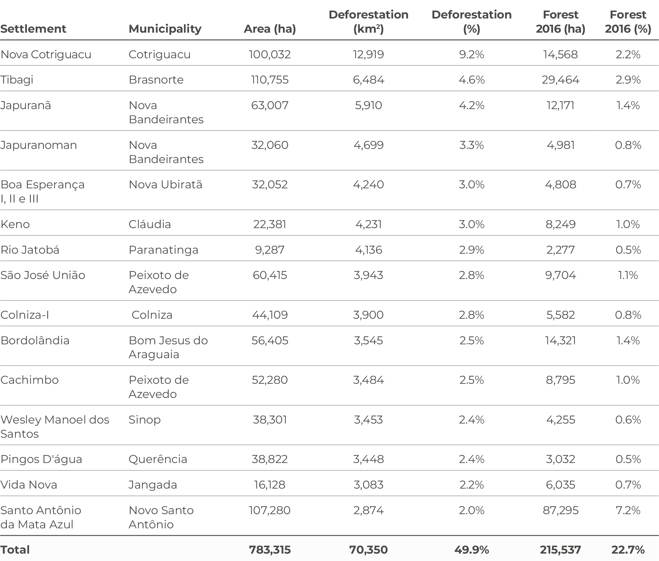
Source: CPI/PUC-RIO with data from PRODES/INPE (2024), INCRA (2023-2024), and IBGE (2019), 2024 Table A8 shows the fifteen settlements with the most deforestation in the Mato Grosso Superintendency. These include the Nova Contriguaçu, Tibagi and Japuranã settlements, which together account for more than 18% of deforestation in the superintendency. It is worth noting that these figures do not include deforestation in Cerrado areas, as this study only considers the loss of primary forest vegetation in the Amazon. Table A8. Settlements with the Most Deforestation in the Mato Grosso Regional Superintendency, 2017-2023
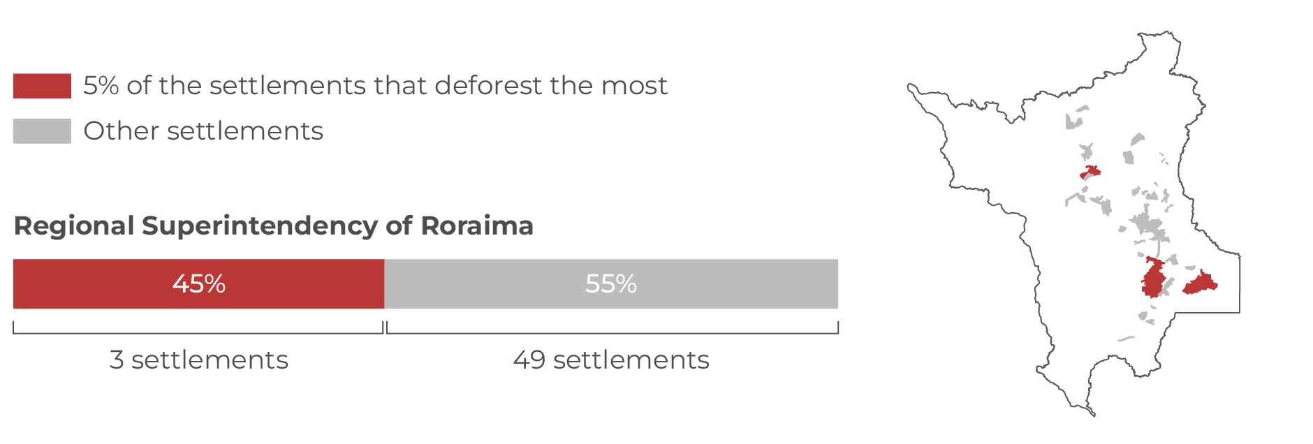
Source: CPI/PUC-RIO with data from PRODES/INPE (2024), INCRA (2023-2024), and IBGE (2019), 2024 Regional Superintendency of RoraimaThe Roraima Superintendency accounts for 5% of forest loss in the Amazon’s settled areas. Between 2017 and 2023, three of its 52 settlements accounted for 45% of deforestation in the superintendency (Figure A7). Figure A7. Settlements with the Most Deforestation in the Roraima Regional Superintendency, 2017-2023
Source: CPI/PUC-RIO based on data from PRODES/INPE (2024), INCRA (2023-2024), and IBGE (2019), 2024 Table A9 shows the fifteen settlements with the most deforestation in the Roraima Superintendency. Among the projects with the largest deforested areas, the Anauá settlement is associated with more than a quarter of the deforestation in the superintendency. The other two settlements, Jatapu and Samaúma, also show significant percentages, adding up to more than 19% loss of native vegetation. Table A9. Settlements with the Most Deforestation in the Roraima Regional Superintendency, 2017-2023
Source: CPI/PUC-RIO with data from PRODES/INPE (2024), INCRA (2023-2024), and IBGE (2019), 2024 Regional Superintendency of MaranhãoThe Maranhão Superintendency accounts for 3% of forest loss in the Amazon’s settled areas. Between 2017 and 2023, 29 of its 580 settlements accounted for 67% of deforestation in the superintendency (Figure A8). Figure A8. Settlements with the Most Deforestation in the Maranhão Regional Superintendency, 2017-2023
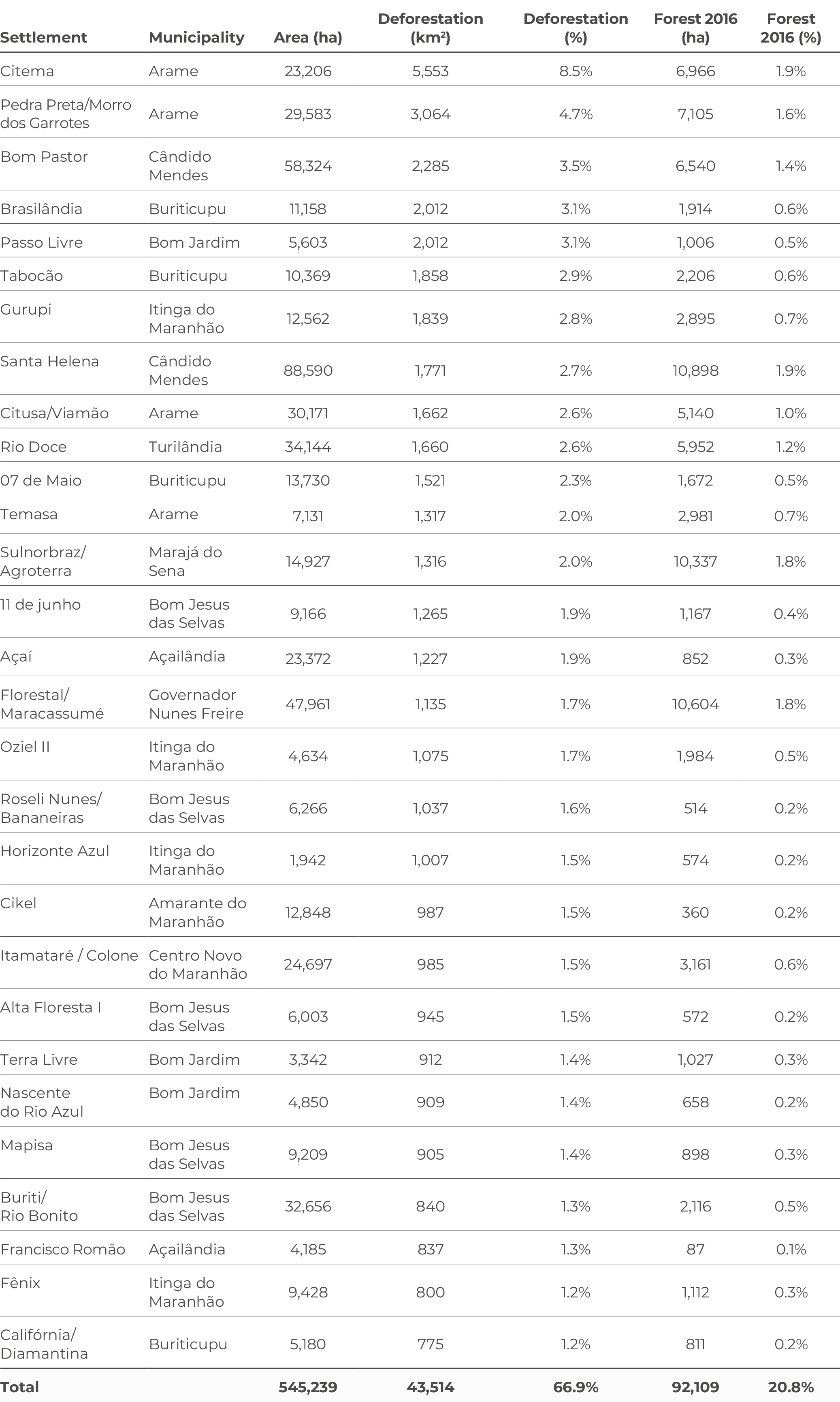
Source: CPI/PUC-RIO with data from PRODES/INPE (2024), INCRA (2023-2024), and IBGE (2019), 2024 Table A10 shows the 29 settlements with the most deforestation in the Maranhão Superintendency. Of particular note, is the Citema Sustainable Development Project, in the municipality of Arame, which accounts for 8.5% of forest loss in the superintendency. Table A10. Settlements with the Most Deforestation in the Maranhão Regional Superintendency, 2017-2023
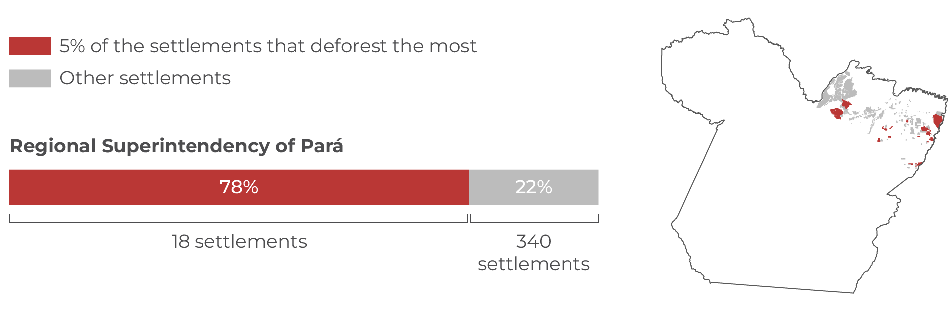
Source: CPI/PUC-RIO with data from PRODES/INPE (2024), INCRA (2023-2024), and IBGE (2019), 2024 Regional Superintendency of ParáThe Pará Superintendency accounts for 3% of forest loss in the Amazon’s settled areas. Between 2017 and 2023, 18 of its 358 settlements accounted for 78% of deforestation in the superintendency (Figure A9). Figure A9. Settlements with the Most Deforestation in the Pará Regional Superintendency, 2017-2023
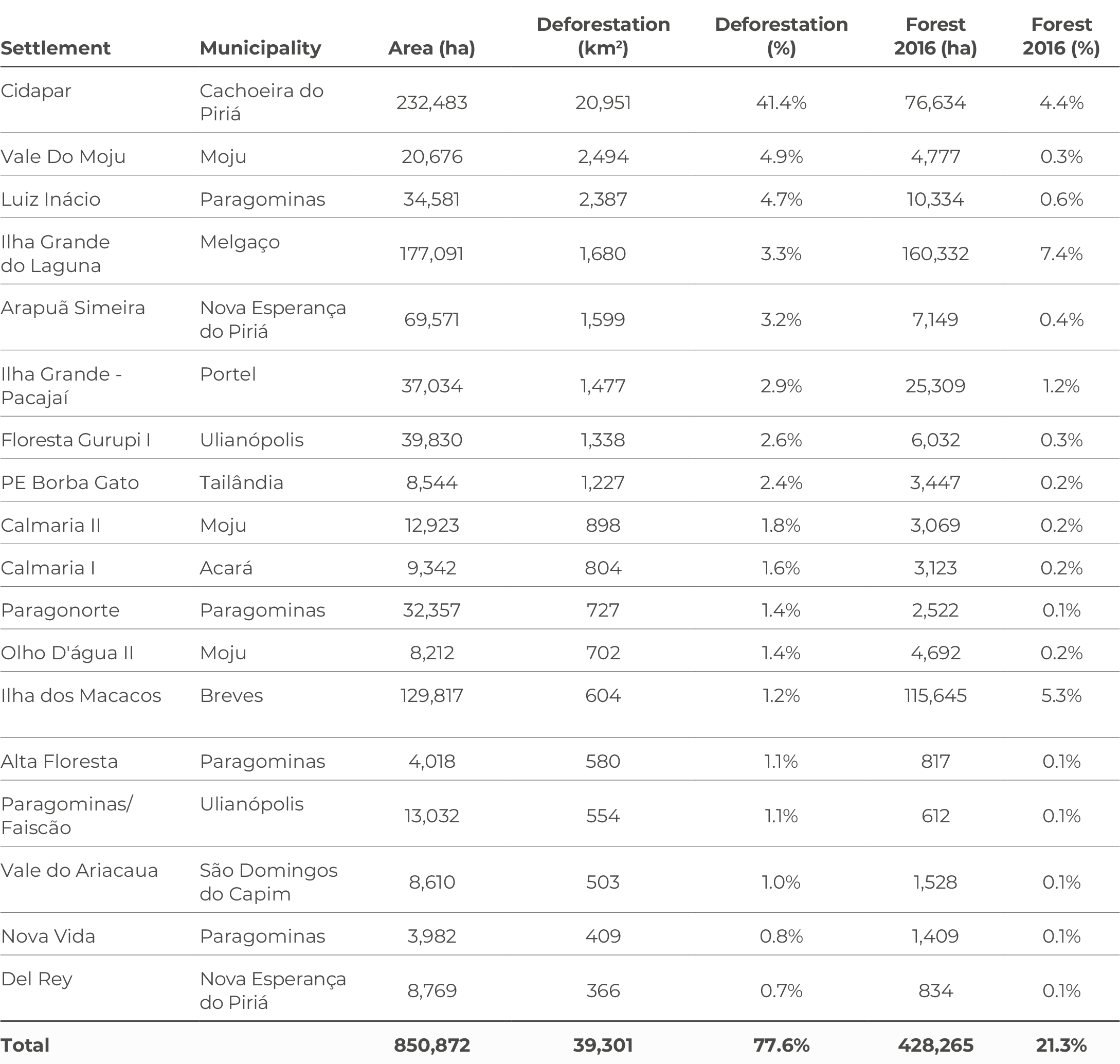
Source: CPI/PUC-RIO based on data from PRODES/INPE (2024), INCRA (2023-2024), and IBGE (2019), 2024 Table A11 shows the 18 settlements with the most deforestation in the Pará Superintendency. Forest loss is highly concentrated in the Cidapar settlement, in the municipality of Cachoeira do Piriá, where 41% of deforestation in the superintendency occurred between 2017 and 2023. Table A11. Settlements with the Most Deforestation in the Pará Regional Superintendency, 2017-2023
Source: CPI/PUC-RIO with data from PRODES/INPE (2024), INCRA (2023-2024), and IBGE (2019), 2024 |
|
| File | |
| Sources | CPI/Resocrces/Publication |
| View Original URL | |
| Prev | [기타] WMO Greenhouse Gas Bulletin No. 20 |
|---|---|
| Next | [SEI] Solar and wind power in Mongolia: 2024 policy overview |


